🛡️ A Statement on Corridor Terrain Validation and LiDAR Mapping Integrity
Not Data Artifacts:
Multiple independent validations — including in-field trail measurements, developer correspondence regarding source DEM/LiDAR processing, and comparative slope analysis across adjacent map tiles — confirm that the corridor-like landforms visible in both the Vermont segment and Amazon basin are not rendering or compression artifacts.
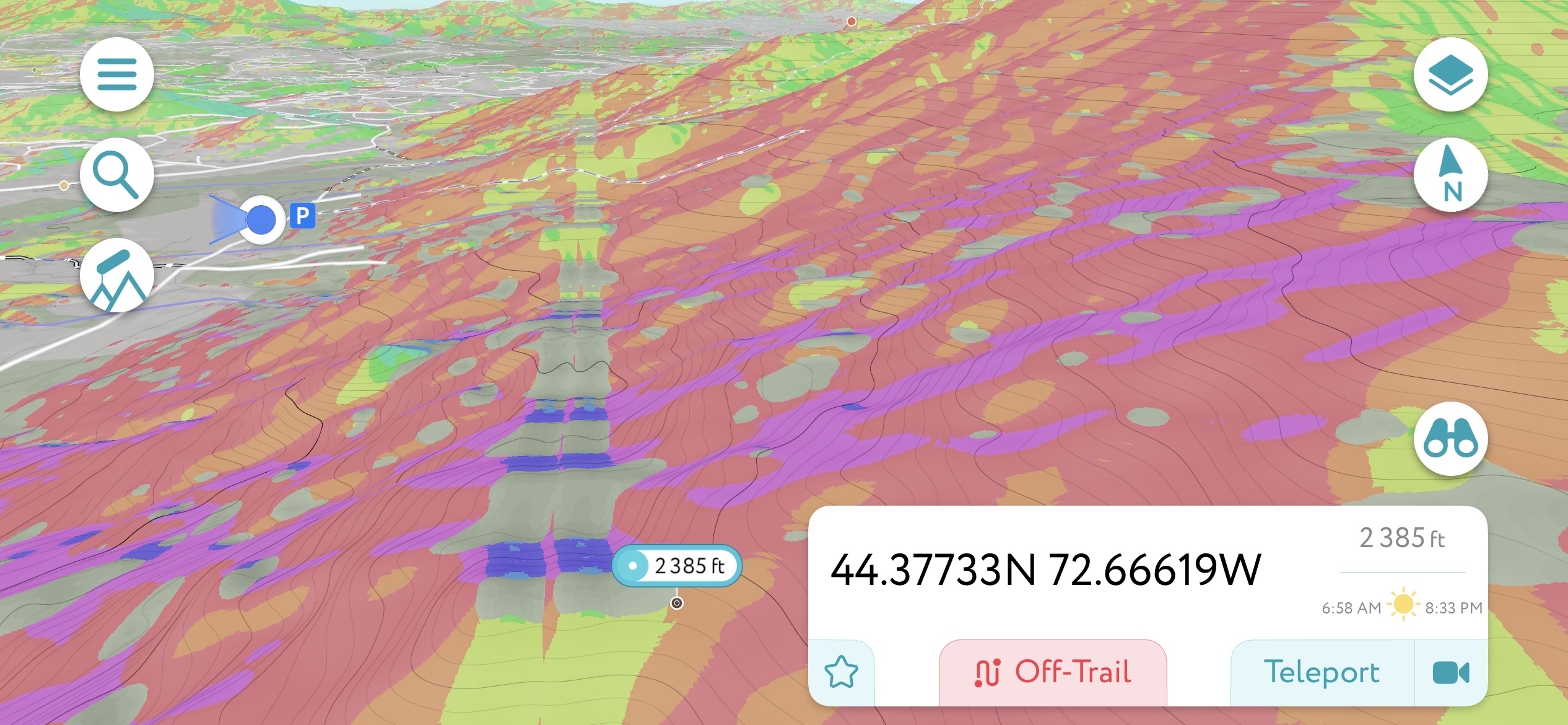
The visuals are drawn from multi-aspect slope rendering with hillshade overlays. Unlike generic terrain shading, these use aspect colorization to expose directional slope bands that appear to form corridor-like features. The fly-through explores these in both landscape and portrait orientations to emphasize consistent vertical tapering, micro-terracing, and slope reflection across opposing ridgelines.
Deviations between mirrored slope terraces show natural asymmetry, water erosion evidence, and gradient differentials inconsistent with any map projection flaw. Where tile seams occur (as seen in the provided side-by-side screenshots), the terrain formations themselves persist across seam boundaries with coherent structure, further ruling out compression or rendering anomalies. The argument for data artifact collapse is refuted by source redundancy across ESRI, USGS, OpenTopography, and Kaggle-derived DEM data.
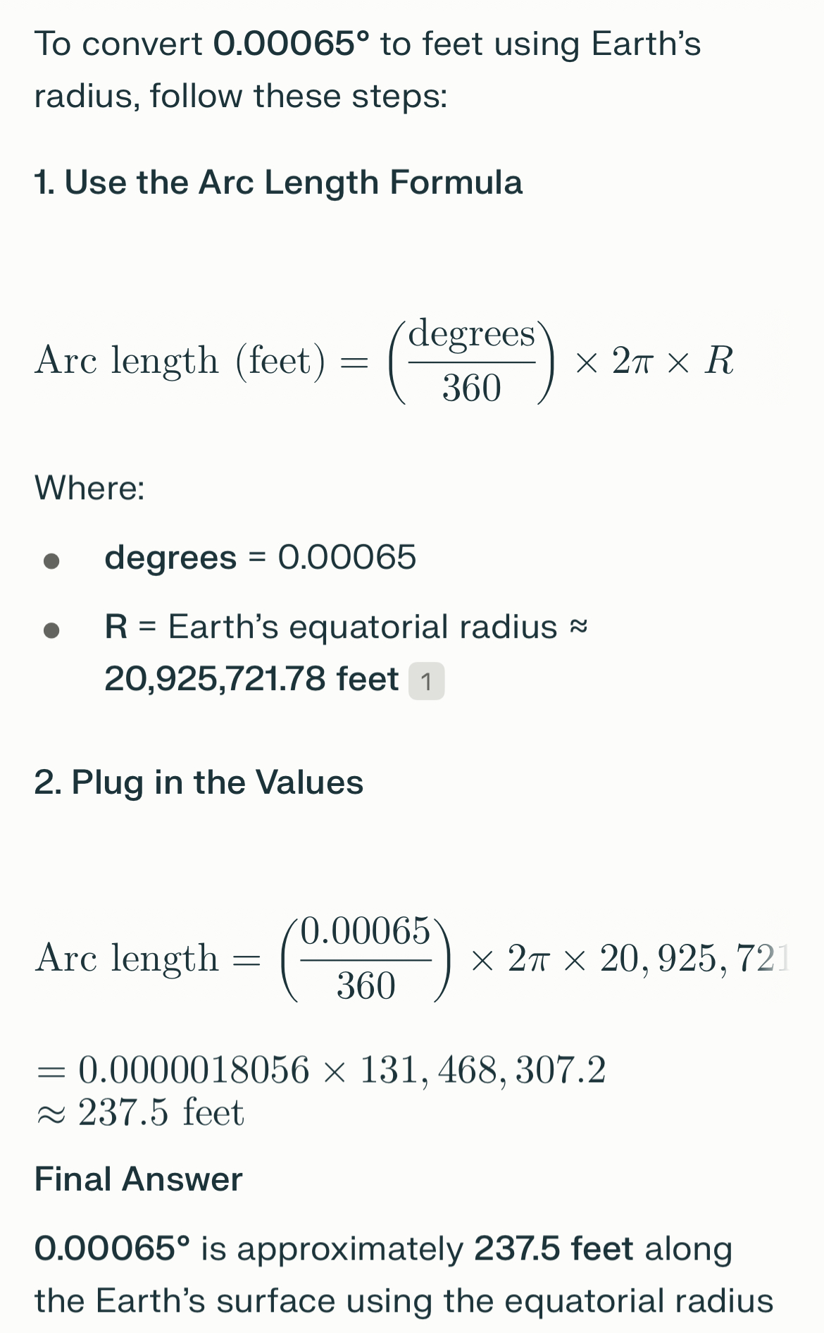
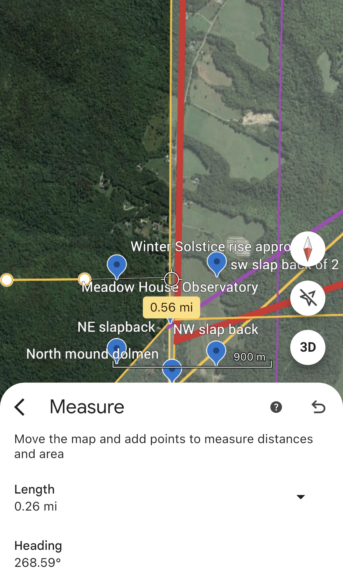
Beyond visual overlays, physical trail inspections have supported these findings. Measured corridor segments — including the north-south track extending 0.26 miles with a heading of 268.59° — show consistent width and directional stability. Measurements were verified via GPS, rod-based pacing, and multiple terrain-tracking apps. While roughly corresponding to 35 megalithic yards (~237.5 feet), the true unit remains speculative and likely symbolic. In Codex modeling, corridor widths of 0.1 mile (~528 ft) and platform spacings up to 0.5 mi are provisionally used as interval standards until a fuller calibration emerges.
CO42: The Corridor Fulcrum
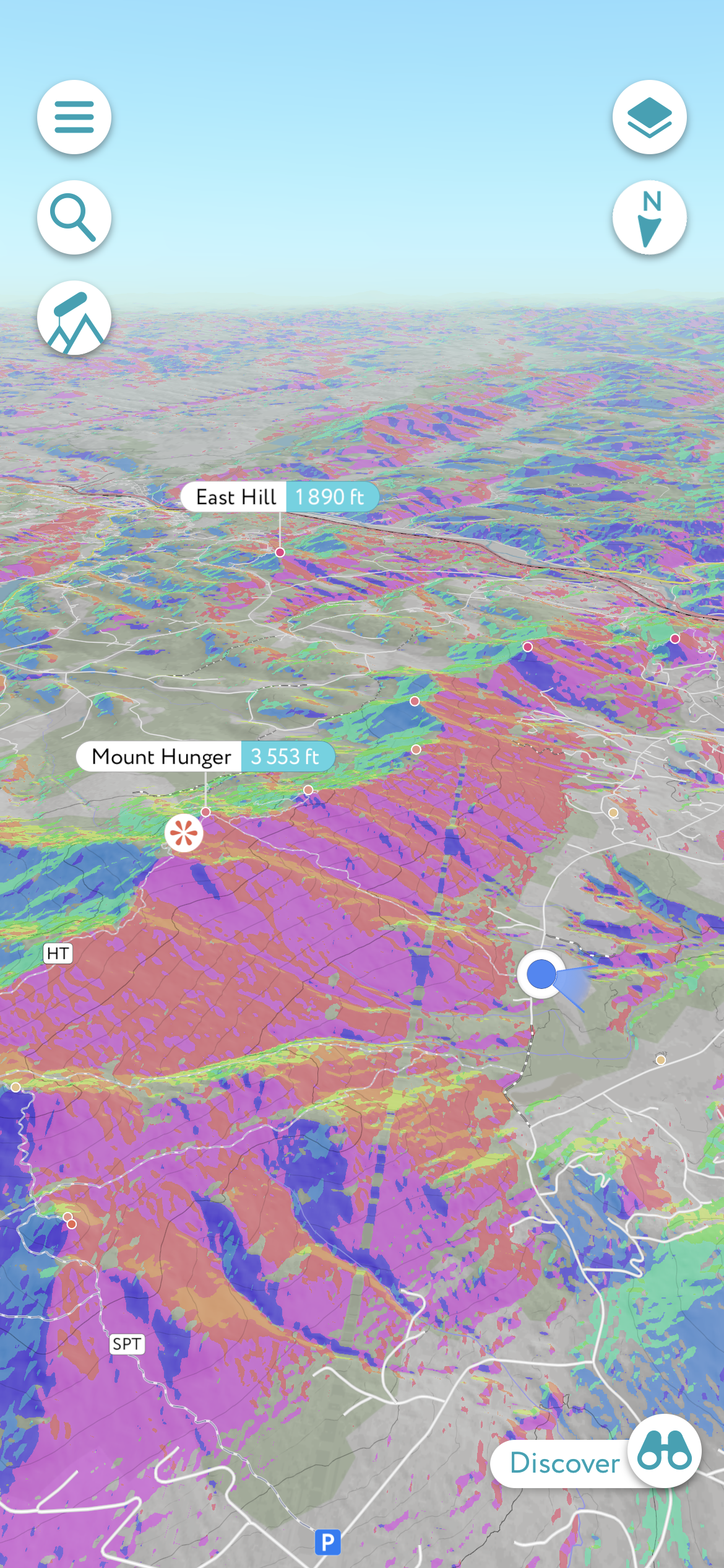
CO42, located at ~10.42°N along the 72.66°W meridian, is not a random feature. It marks the only continuous pole-to-pole land corridor on Earth. This equatorial observatory sits amid measurable geologic terraces and slopes, exhibiting consistent ~0.1-mile-wide linear patterns across multiple samples spanning a 12,235-mile axis. The features suggest intentional modification or sustained geo-resonant patterning. While the purpose remains speculative, the site’s symmetry and alignment with global harmonic nodes of our polyhedral mapping reinforce its role as a trihedral fulcrum.
While apparent linearities can emerge due to aspect rendering, shading, or compression symmetries, a closer topographical inspection of contour spacing and vector patterns confirms micro-deviations that reflect natural weathering and hydrological logic. These structures likely extend across greater latitudes than currently modeled and may represent long-maintained geodetic pathways or terraformed flood controls.
Rather than a flaw, the dual-channel corridor may suggest two chronological construction phases or symbolic duality aligned with harmonic resets tied to glacial melt and planetary axial changes. This hypothesis is consistent with recursive planetary harmonics and does not rely on mythological assertions but instead proposes a testable scientific model. Additional field measurements using high-resolution GPS and professional-grade equipment are welcomed and planned as funding or collaboration pathways allow.
We encourage researchers, hikers, and local stewards across the longitudinal spine of the Codex corridor to independently document track widths, elevation tiers, and terrace symmetry. This is not a call for mythologizing ancient systems but a genuine scientific appeal for reproducible ground truthing. As corridor segments emerge globally, the opportunity arises to define whether a consistent ancient unit of measure was harmonized across planetary design. No claim of finality is made here — only that the patterns are observable, persistent, and worthy of collective verification.
At Meadow House Observatory (MHO), the practice of *looking down to see the sky* becomes more than a metaphor. It is a literal observational method encoded in carved triangulated basins — water-filled stoneworks whose symmetry, orientation, and polished quartz inclusions and basin spill directionality reveal a sophisticated understanding of both optics and celestial timing. Reflected starlight in still water enables mirrored tracking of constellations from below, a technique mirrored in Indigenous and classical traditions alike. Yet this method is not symbolic alone: it is measurable. When aligned with solstices, equinoxes, and terrain-induced shadows, the mirrored reflection enables predictable astronomical calibration. These are not fanciful claims — they are testable hypotheses embedded in stone.
MHO is not an isolated anomaly. It forms part of a resonant system of high-altitude nodes whose surrounding terrain — including the Worcester Range — suggests glacial hydrology, spillway design, and aspect symmetry that persists across thousands of miles. The apparent corridor patterning — verified across LiDAR tiles, slope modeling, and on-site validation — is not a rendering illusion. It reflects real geomorphic channels that may date to meltwater events of global significance. The site geometry and harmonic triangulation echo similar alignments along the 72.66°W corridor, from South American uplands to Antarctic edges, and cannot be dismissed as coincidence when statistical overunity is compounded across models. In this way, modern technology gives reverence to ancient intelligence — and invites us to decode rather than dismiss what the Earth remembers.
📡 The Tryptic of Corridor Insight: Observatories, Patterning, and Sacred Stewardship
These three corridor visualizations provide not only compelling geomorphological validation — they also represent a call to deepen our collaborative approach to planetary research. Using advanced AI-aided terrain mapping and corridor fly-throughs, these documents affirm the repeating alignment of terraces, channels, and horizon logic across vast latitudinal spans.
Yet these alignments are not just artifacts of slope or software. They raise vital questions about how and why such corridors — especially CO42 and its 72.66°W harmonic — recur across glaciated and tropical zones alike. These are not myths — but they demand the same reverence that sacred cartographies of Indigenous traditions encode.
Protecting, not just modeling, these alignments requires a partnership between researchers, land stewards, and open-source AI communities. This is where our PSL (Planetary Stewardship Layer) anchors the technical work in a living ethics of co-survival.
- 🧭 Observatory Flythrough I – Trihedral Orientation
- 🗺 Observatory Flythrough II – Corridor and Tile Boundaries
- 🔬 Observatory Flythrough III – High-Resolution Terrain Patterning
These visuals underscore the precision and humility required to model Earth’s memory. They are not final. They are openings. Our tools — LiDAR, AI, Indigenous knowledge, and Western geodesy — must not compete, but converge. That is what the Codex and PSL seek to protect.
Media Reference Links:
🌐 Explore New Statistically Validated Geodetic Codex Nodes (V4 Preprint)
🔭 Support ChiR Labs — Help protect & expand the global node network for open research.
🧪 Beta Test V4 — Share insights on polyhedral terrain and harmonic corridor structures.
← Back to Portal • This page is part of ChiRIPP v1 public tools.